Thursday, December 5, 2019

When Tourism Reigned

The Ocean Shore Railroad in it's beginning was expecting a large influx of tourists, flocking from the cramped city of San Francisco to the sandy beaches of the San Mateo Coast. This dream, which was built upon developing real estate for these wealthy tourists is what cost the Ocean Shore Railroad it's life. In the beginning, the tourism was slow to start, but got to the point so much that the OSRR had no choice but to put tourists on flatbed cars with benches! These following pictures display a time when Tourism reigned on the Devil's Slide portion of the line.

The location is most likely somewhere after the Pedro Point Tunnel. This image, not sure how the photographer had gotten there, shows what can be presumed as an Ocean Shore Railroad commuter train along the Slide.

Approaching the Pedro Point Tunnel can reveal the relationship with Humans and the development of a railway along a constantly changing coast. Sure would be a wonder if this were still around.

Of course, tourism was so much from the wealthy people of San Francisco, that the Ocean Shore Railroad had to leave people on flatbed cars with benches!

The Devil's Slide caused more problems on its own than during construction. Landslides plagued the cliff, as by its name. It trapped many trains when it ran, yet one can only imagine being stuck on a cold train by a landslide, with the fear of it plummeting to your death.

The caption on the picture reads:

"This photo shows the nature of construction in the Devil's Slide area by the Ocean Shore's contractors. But, this is not a construction image. It is actually a photo of crews battling to free a train trapped by a landslide at this notorious slide area. The San Pedro Point tunnel portal is a dark spot on the far left mountain going out of the ocean."


Advertisements by the Ocean Shore Railroad ran rampant through newspapers, encouraging those who wanted to escape the bleak city life of San Francisco to ride the train down South. Of course, this barely even worked.

Possibly the most famous phrase of all Ocean Shore Railroad advertisements: "Reaches the Beaches!"

SOURCES:

I gather my images mostly from Oceanshorerailroad.org and Half Moon Bay Memories. Just to be clear, I do NOT own any of these. Sorry for the un-bibliographical phrases here, the website I usually use to make the websites and authors look biblical is down. 


Saturday, November 23, 2019

The Treacherous & Infamous Devil's Slide

A monument to engineering, and a feat that was unsurpassable by any other railway in the Bay Area of California. It is the most charming aspect of the Ocean Shore Railroad, and possibly the most infamous. We know Devils Slide today as the treacherous stretch of road that the Cabrillo Highway went through, plagued by storms and landslides. Since the opening of the Tom Santos Tunnel, the former route of the Cabrillo Highway has been turned into a pedestrian path, designated as a rail-to-trail. Though it may seem steep for a railway to incline it, the Ocean Shore Railroad actually did not go above the Devils Slide, it clung to a ledge on it. Just like the ledge, we observed in San Francisco, the railway wrapped around the Devils Slide, via the Pedro Point Tunnel, and came out on Pacifica. The landslides were partially the reason that the Ocean Shore Railway was driven to bankruptcy.

The route of the Pedro Point Tunnel, transitioning from a noticeable right of way clinging to a ledge, to a simple flat line along the cliffs.

It was the entire plan of the Ocean Shore Railroad to connect San Francisco and Santa Cruz via the coast. It was not an easy task, and engineers knew that the Devils Slide would be the hardest portion of the line. When the line to El Granada was completed, engineers hailed it as a miracle. They claimed that the rest of the line was going to be a breeze building, but as Chris Hunter stated, "It was not the cast."

The Devils Slide portion of the railway was completed in 1907, after tirelessly using work gangs and steam shovels to carve out a berm to the side of the cliffs. The work was tiresome, especially when plagued with the 1906 earthquake, which effectively threw the railway equipment to the side. 

The work gangs, which were primarily Greek, carved out a ledge.

The railway used the Pedro Point Tunnel to access the Devils Slide. From here, on google maps, we can see the railway curve, as well as a ground displacement and rubble, from when the tunnel was blown up by federal agents in the 1930s. I will make a post up on that later. 


Above, we can observe the remains of the ledge, and the condition it is in. Since abandonment in the 1920s, it has been plagued from the constant pounding of ocean surf, and the changing formations of the cliffs. It is virtually impossible nowadays, to get to the ledge, and to revitalize it. 


A sideways look of the ledge reveals the chaotic condition it is in that the ledge is in. If only the workers of the time came back to see their engineering feat, a masterpiece, crumbling away.


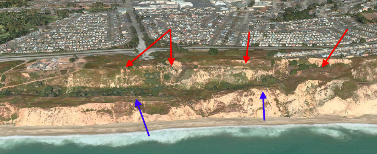
Then, the line curves from the straight stretch on the Slide. In the photo shown above, the curve is relatively destroyed, from watershed creeks and landslides from previous years. When trains rolled across it, the view was spectacular. The below picture is a view from the Rockaway Beach curve, but the right of way of the Ocean Shore Railroad is still noticeable. This view greeted weary travellers and beach-goers, to a land of opportunity. Much of the towns of the San Mateo coast can be credited to the Ocean Shore Railroad's aggressive marketing campaign, in conjunction with Real Estate Companies that sought to sell flatlands, to ease the house congestion of San Francisco.

Only this view remains, as in our post of the Rockaway Beach section, using a very steel trail this ledge is accessible, cut away from the rest of the berms.


The railway then follows a certain, relatively, straight stretch of track. Travellers on the Ocean Shore Railroad could only look two ways, face a rocky cliff, or face the majestic bright blue Pacific Ocean. The railway used a variety of cuts to pass along the cliff, to make a cheaper option in building the line. Though it would cost them bankruptcy, it provided the railway with tourism for a couple of years. One can dream though, that if the railway made it to through the Roaring Twenties, that thousands of tourists could have flocked to areas like Linda Mar, and Tunitas Creek. If the railway had persevered through the Great Depression (just like much of the right of way and bridges), it would've provided agricultural transport, and if the railway had made it into World War Two and the Cruisin' Era, tourists and industry would flourish among the coast. 

Possibly the most famous picture from the Ocean Shore Railroad. This view can observe a passenger train along the slide.

Landslides like these plagued the Ocean Shore Railroad, just like it did to the Cabrillo Highway.


The railway then continued, probably curving along that big stump shown in the above screenshot. Most of the area nowadays has eroded away, but a faint line that resembles the ledge remains. The cuts are sort of visible, though may have become formed with landslides over time.


A close up to the line reveals the faint trace of the ledge, as well as multiple rocks jutting out from the once laborious tasks of cutting into the hillside.


Yet, as it continues, traces of the berm becomes more and fainter. At this point, it has disappeared from the constant erosion of the ocean shore. However, I believe that white line to the right of the image could be the ledge. I imagine that the Cabrillo Highway built atop that certain section of the line (as we do have knowledge that the sections of the Cabrillo Highway between the Tom Santos Tunnel and Half Moon Bay were indeed used by the Ocean Shore Railroad), leaving only a white rock trace of it. 


It can be imagined though, for the Cabrillo Highway descends into the area where the white line follows and the ledge. Technically, this portion of the line is the best-preserved, as the cuts still remain. In the right, we can see the large railway cut that was blasted by the engineers, later widened to accommodate the highway. I have visited this area myself, thanks to the transformation of the highway to a pedestrian walkway, and can reveal that the cuts are tall!

I can presume this is the approximate location. This image reveals the sheer size of the cuts, in comparison to the passing commuter train. 

An image, taken by me, reveals the size of the cuts. This is at the entrance to the trail, a little bit further from our current position.


The line then curves, via multiple cuts shown in the image, to where the Tom Santos Tunnel is now located. Originally, these were supposed to be a series of tunnels, which I presume would have been much safer, but the engineers decided to use the much cheaper version. The image that I took, above this screenshot, reveals the size of this. I have walked the entire trail (very tiresomely I must add), and can say that these huge! Unfortunately, I must leave you all here today readers. If you are wondering about my uploading times, I upload when I please and when I have the time. 

A little photo, to tell you what there is to expect in the next posts!

Thursday, October 17, 2019

Wavecrest Ledge to Devils Slide

It is possibly the most enchanting aspect of the Ocean Shore Railroad, that was the line that curved around the precarious Devils Slide. Blasted from the rock, with the aid of work gangs and steam shovels it was possibly the hardest part in completing the railway. As it did to the Cabrillo Highway (before they built the tunnel), landslides plagued the line; often shutting it down for weeks on end. One can only imagine what it would be like traveling through there during a windy stormy day. This section will be covering the line from Wavecrest (Pacifica) all the way to Devils Slide, stopping at where the Pedro Point Tunnel once was.


The tracks curved from Wavecrest and climbed a [unknown] grade, with the help of the ledge. As you can see, parts of the ledge have collapsed, eliminating the only road into Tobin and Shelter Cove. Remains of the road can be found on the ledge itself. It should be known that if the ledge had not collapsed, the people of Pacifica may have found a new beach destination like they did in the fifties.

The collapse is much more visible now, after constant years of Ocean Shore pounding.

The line curves around the mountain again, around Tobin and Shelter Cove. The site of where the Tobin station was is marked by the strange concrete circle, with Shelter Cove's once-famous beach lying beside it. Since the road collapse, the only way to enter the cove was via a small footpath, bringing tourism to the area as well as the small resort that was there to dwindle. There is small evidence of the asphalt road that once carried cars to Shelter Cove, but now carry only people and the wildlife that live there. 


A closeup upon the cut that was at Tobin, reveals the former road and where the Tobin station once stood. The path at the bottom was once there, to lead the people of the parked cars down to the seaside resort that was at Shelter Cove.


It is from here that the line curves to follow the mountainside, with much evidence of the railway being shown. If only this was the case on the other side of these treacherous hills. Since the abandonment in the 1920s, the line has faced much erosion and collapse. Some long-living residents of Pacifica recall riding their bikes on the ledge during the thirties to the then uncollapsed tunnel.

The spot where the Pedro Point tunnel once was, curving around Mussel Rock is evident.

From there, the Ocean Shore Railway would continue on the ledge until the Pedro Point Tunnel, which provided curved access into the other side of Devils Slide. Many legends surrounded the tunnel, as will be the interest of the next post but possibly the most famous was that the tunnel was possibly (probably) used for alcohol boot-legging during the times of prohibition. After that, federal agents blew up both entrances to the tunnel. The curved indent at the top of the hill shows where the ground shifted after the tunnel was blown, but maybe there are still pieces of wood or just empty space in all that rock. Quite fascinating, so until the next post readers! 

The station at Tobin, date unknown. The station now serves a private residence. 

Sunday, October 6, 2019

Sharp Park to Wavecrest

Sharp Park, once a community now part of Pacifica, was possibly one of the greatest areas for a business venture to ever occur. By the time the Ocean Shore Railroad arrived, a few buildings for residents were there. The best way to follow the Ocean Shore Right-Of-Way is to follow the Cabrillo Highway from Sharp Park all the way to Rockaway Beach. From the Ocean Shore School, the line is practically un-seeable after decades of recent development and renovations. The curve of the Cabrillo Highway may be following the right of way, but without the aid of historical maps of the area, it is practically untraceable. However, one that we do know from our sources, is that the big cut that the Cabrillo Highway uses to get into Rockaway (see picture below), was at first blasted out by Ocean Shore Railroad engineers, and later expanded to carry the highway.

The massive cut that once held the railroad now holds the cars.

I can assume that the side of the cut on the right, with more trees and foliage, is the original cut. It is crazy, to find that many people travel through this; not knowing the history that it had. One interesting this is, that Cabrillo Highway actually reaches the community of Vallemar, an important and well-known destination on the Ocean Shore Railroad. In fact, an Ocean Shore railroad station for Vallemar still survives there! Though the station presumably was moved, it has been renovated and restored to its former glory. Beside it though, the community of Vallemar has embraced it's railroad past by providing two railway cars, unclear which railways or railway they were from. I have traveled through the area myself, and google maps tell the same story as I saw. There is an orange-painted boxcar, along with a classic-red caboose on another lot, both being restaurants.

Blue = Station. Red = Unknown Railroad Cars. Black = Presumabley Ocean Shore Railroad ROW

From there, we can only assume that the Ocean Shore Railroad follows the Cabrillo Highway, all the way up to Rockaway Beach. From Rockaway Beach, if you were to stand there and look south you wouldn't find any remains of the Ocean Shore, however, the line curves on the Rockaway Headlands, and you can still see some remains. Though the pounding of the ocean waves has eroded much of the line, there are still remains around the Rockaway headlands. 

The line curves around the headlands, mostly eroded but still a little visible.

From the image, there seems to be a gravel path that would've carried the Ocean Shore tracks around the headlands. It is a shame that the ocean waves eroded much of the line around the headland, as it would've provided quite the treacherous view! I guess that is a fault of having a railway run on the 'Ocean Shore'. Though much of the line is eroded, there is a little trace of the ledge on the other side of the headlands.


As you can see on the left, there are small remains of the ledge, not yet demolished by the ocean waves. It is from this, that the line curved into the city of Wavecrest, now commonly known as Pacifica. The line at the time would curve around the [Pacifica State] beach. There is no trace of the station at Wavecrest, presumed to be demolished after the line was abandoned. It is here, that our current exploration stops, and waits until the next time!

If you can see a little, the line curves around the beach, with a little glimpse of the line to Devils Slide on the right!

(Top) A Ocean Shore Train in Brighton Beach.
(Below) A Passenger Train of the Ocean Shore, at an unknown wye location. 

It would be nice to know the whereabouts of the wye in the below picture! Leave a comment please if you have any information.

SOURCES:
 Hunter, Chris. Ocean Shore Railroad. Arcadia, 2004.
Morrall, June. “Experts: Is This the Ocean Shore RR? What about the Paper Cities?” Pescadero Memories, 17 May 2009.
“Ocean Shore Railroad.” Wikipedia, Wikimedia Foundation, 24 July 2019.


Friday, October 4, 2019

The Ledge Revisited

It appears that going back on Google Maps to look at the Ocean Shore Railway's ledge in San Francisco, shows a much different outcome out of the suspicion that I had thought of. I was, in fact, mistaken, in my suspicion that the Ocean Shore Railway used a man-made causeway to reach Daily City & San Francisco up above, using a steep grade to get up the cliffs. In reality, when zoomed in the railway actually curves along with the ridge, leading to a now collapsed secondary ledge where it would slowly reach up to San Francisco above.
The blue arrows show what I originally thought, whilst the red arrows show my new revelation.

In the Chevalier Map, it shows that the railway had curved from the ledge into the city of San Francisco, which I thought matched up with my suspicion. I am unaware of any photographs that were taken on the ledge in San Francisco as stated in the past post. In the Chevalier Map below, we can see that the ridge shown in the red arrow in the center of the photo, was not in fact there when the Ocean Shore Railroad came though, possibly an effect of at least 90 years of neglect after abandonment. 
The geographical lines prove that there was no ridge and that the railroad did curve.

As shown, the ledge curves and meets the collapsed section of the ledge.

In the picture above, we see the line actually curve, meeting what seems to be rubble and debris from a collapsed section of the cliff that it tried so hard to carve into. Near to the center top of the picture, you can see more remains of the ledge curving once again, this time almost near the city of Daly City & San Francisco. 

In the picture above, we can observe that the ground is relatively in the same grade when the ledge approaches. We, of course, can only assume this is correct as a massive landslide blocks the way of the original track. At the chevalier map, we can see the line curves to the right. After ninety years, the line is pretty much un-traceable into the city from recent development. One thing we do know, however, is that Ocean Shore Trains entered San Francisco via Alemany Blvd. Thus, this ends the revisitation of the ledge in San Francisco. I hope to visit this spot soon, and take photos for you all! 

SOURCES:
Hunter, Chris. Ocean Shore Railroad. Arcadia, 2004.
Chevalier Map of San Francisco - 1912 

Wednesday, September 18, 2019

A Ledge in San Francisco

For the tracing of the noticeable sections of the Ocean Shore Railroad, we will be starting in where it is the most noticeable from Google Maps. For a basis, I will be using the Chevalier Map of San Francisco (1912). After we cover the noticeable sections of the surviving Right of Way in this series, we will be moving on to covering San Francisco, using the map. As shown in the image below, we can observe that the Ocean Shore curves and enters a ledge against the Pacific Ocean. There also seems to be two black spots that I can't quite understand what it means. It seems the tracks have to enter a sort of grade incline in order to reach the ledge. 

The ledge in San Francisco is noticeable in this Google Maps picture.

The screenshot dated 2019 shows what supposedly is the grade. If you look closely you can see the embankment that the Ocean Shore used to get up to San Francisco. On the right, you can see the beginning remains of the ledge now. It is unfortunate that I could not find any pictures of the San Francisco ledge.
A bigger photo of the San Francisco ledge, in the middle it seems that either the area was eroded away by the constant pounding of the ocean surf, or that the ridge was there before the Ocean Shore, and that the railway built a trestle in order to traverse it. As you can see, erosion has removed parts of the ledge, and dirt has piled upon it. Wouldn't it be a sight if the railway were still using that ledge today? 

Continuing on, the next section of the ledge ends in what seems to be just another ridge along the coast. However, there is a recent development in that area, possibly for a park. Proven by the parking lot on the right. I assume that the ledge ended there and that either a small causeway or trestle were made? Either way, the tracks continue presumably on what is the road to the right beside the coast. 

A closer picture on the road, with what I think was the Ocean Shore right of way back then, with the tracks continuing straight through Wavecrest (Pacifica). From then through the city of Wavecrest, the right of way is hard to trace. The only marker we can use is the newly named Ocean Shore School, who's playground was supposedly on the Ocean Shore Railroad right of way, causing a lawsuit which eventually renamed the school!
Here is a picture of the Ocean Shore School, which now concludes the first part of our tour of the remains of the Ocean Shore Railroad. I hope you stay tuned!


Trains left San Francisco on what is today Alemany Blvd. Note the cut in the distance.

Sunday, September 15, 2019

A Short Note

The landscape of which the Ocean Shore Railroad ran along, has not really changed in the forms of geography (minus the ever-changing coastline). Though when the railway came, the town of Half Moon Bay was just a mere settlement, it was formed entirely to expand upon that. Taking photos side by side from the years when the railway ran, to now [2019], it is quite noticeable that there is an influx of homes all along the coast. Massive fields of empty fields still engulf the San Mateo coastline, all the way down to Santa Cruz. 

I am in no way an experienced historian of the Ocean Shore Railroad, this blog is entirely dedicated to simply just documenting an idea; an idea that was too early for its time. Facts may be wrong in this blog, and I apologize for it. The history of the line is troubled, as much of the legal documents that covered the railway's founding, were burned when the Great 1906 Earthquake of San Francisco hit. This blog is just a sharing point for my current knowledge of what remains of the Ocean Shore Railroad, and maybe perhaps what I could learn. 

So, with all that in mind: Let's begin. 


Filling a swamp with City debris after the 1906 Quake. 

Introduction


It was what some people called, a magnificent failure. It was an idea too early for its time, fueled only by investors and real estate agents hoping to build upon the flat land that was the coastline. It battled challenges all of its life, whether it was the precarious Devils Slide or the Southern Pacific, it always fought for its hold. One can only imagine what the possibilities that the Ocean Shore Railroad would've provided if it were still here today! It would put an ease to the constant vehicle traffic that plagued the Cabrillo Highway now, and make it easy for commuters to get from their homes in Half Moon Bay to San Francisco. A thought so relished upon now, but too expensive. One can only dream.

Tracing the remains of the Ocean Shore Railroad is not an easy task. Much of the Right-Of-Way has been heavily weathered since the abandonment of the line in the 1920s. If you look closely, however, on Google Maps, you can find where the original line went.  Though the trestles have long since-


Engineers building the railway, in order to get from San Francisco to their desired destination of Santa Cruz had to tackle Devils Slide. It took them months to battle the steep cliffs of the slide, but they eventually carved a ledge that finally allowed trains to come from San Francisco, into Half Moon Bay.


- collapsed and the ledges long since eroded, the line and the cuts still remain. This blog exists entirely to remember the Ocean Shore Railroad (or Railway), as a sort of archive to give history on a railway often looked over.