Thursday, October 17, 2019

Wavecrest Ledge to Devils Slide

It is possibly the most enchanting aspect of the Ocean Shore Railroad, that was the line that curved around the precarious Devils Slide. Blasted from the rock, with the aid of work gangs and steam shovels it was possibly the hardest part in completing the railway. As it did to the Cabrillo Highway (before they built the tunnel), landslides plagued the line; often shutting it down for weeks on end. One can only imagine what it would be like traveling through there during a windy stormy day. This section will be covering the line from Wavecrest (Pacifica) all the way to Devils Slide, stopping at where the Pedro Point Tunnel once was.


The tracks curved from Wavecrest and climbed a [unknown] grade, with the help of the ledge. As you can see, parts of the ledge have collapsed, eliminating the only road into Tobin and Shelter Cove. Remains of the road can be found on the ledge itself. It should be known that if the ledge had not collapsed, the people of Pacifica may have found a new beach destination like they did in the fifties.

The collapse is much more visible now, after constant years of Ocean Shore pounding.

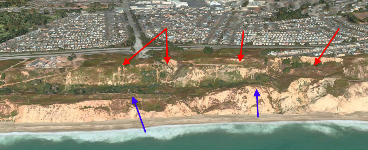
The line curves around the mountain again, around Tobin and Shelter Cove. The site of where the Tobin station was is marked by the strange concrete circle, with Shelter Cove's once-famous beach lying beside it. Since the road collapse, the only way to enter the cove was via a small footpath, bringing tourism to the area as well as the small resort that was there to dwindle. There is small evidence of the asphalt road that once carried cars to Shelter Cove, but now carry only people and the wildlife that live there. 


A closeup upon the cut that was at Tobin, reveals the former road and where the Tobin station once stood. The path at the bottom was once there, to lead the people of the parked cars down to the seaside resort that was at Shelter Cove.


It is from here that the line curves to follow the mountainside, with much evidence of the railway being shown. If only this was the case on the other side of these treacherous hills. Since the abandonment in the 1920s, the line has faced much erosion and collapse. Some long-living residents of Pacifica recall riding their bikes on the ledge during the thirties to the then uncollapsed tunnel.

The spot where the Pedro Point tunnel once was, curving around Mussel Rock is evident.

From there, the Ocean Shore Railway would continue on the ledge until the Pedro Point Tunnel, which provided curved access into the other side of Devils Slide. Many legends surrounded the tunnel, as will be the interest of the next post but possibly the most famous was that the tunnel was possibly (probably) used for alcohol boot-legging during the times of prohibition. After that, federal agents blew up both entrances to the tunnel. The curved indent at the top of the hill shows where the ground shifted after the tunnel was blown, but maybe there are still pieces of wood or just empty space in all that rock. Quite fascinating, so until the next post readers! 

The station at Tobin, date unknown. The station now serves a private residence. 

Sunday, October 6, 2019

Sharp Park to Wavecrest

Sharp Park, once a community now part of Pacifica, was possibly one of the greatest areas for a business venture to ever occur. By the time the Ocean Shore Railroad arrived, a few buildings for residents were there. The best way to follow the Ocean Shore Right-Of-Way is to follow the Cabrillo Highway from Sharp Park all the way to Rockaway Beach. From the Ocean Shore School, the line is practically un-seeable after decades of recent development and renovations. The curve of the Cabrillo Highway may be following the right of way, but without the aid of historical maps of the area, it is practically untraceable. However, one that we do know from our sources, is that the big cut that the Cabrillo Highway uses to get into Rockaway (see picture below), was at first blasted out by Ocean Shore Railroad engineers, and later expanded to carry the highway.

The massive cut that once held the railroad now holds the cars.

I can assume that the side of the cut on the right, with more trees and foliage, is the original cut. It is crazy, to find that many people travel through this; not knowing the history that it had. One interesting this is, that Cabrillo Highway actually reaches the community of Vallemar, an important and well-known destination on the Ocean Shore Railroad. In fact, an Ocean Shore railroad station for Vallemar still survives there! Though the station presumably was moved, it has been renovated and restored to its former glory. Beside it though, the community of Vallemar has embraced it's railroad past by providing two railway cars, unclear which railways or railway they were from. I have traveled through the area myself, and google maps tell the same story as I saw. There is an orange-painted boxcar, along with a classic-red caboose on another lot, both being restaurants.

Blue = Station. Red = Unknown Railroad Cars. Black = Presumabley Ocean Shore Railroad ROW

From there, we can only assume that the Ocean Shore Railroad follows the Cabrillo Highway, all the way up to Rockaway Beach. From Rockaway Beach, if you were to stand there and look south you wouldn't find any remains of the Ocean Shore, however, the line curves on the Rockaway Headlands, and you can still see some remains. Though the pounding of the ocean waves has eroded much of the line, there are still remains around the Rockaway headlands. 

The line curves around the headlands, mostly eroded but still a little visible.

From the image, there seems to be a gravel path that would've carried the Ocean Shore tracks around the headlands. It is a shame that the ocean waves eroded much of the line around the headland, as it would've provided quite the treacherous view! I guess that is a fault of having a railway run on the 'Ocean Shore'. Though much of the line is eroded, there is a little trace of the ledge on the other side of the headlands.


As you can see on the left, there are small remains of the ledge, not yet demolished by the ocean waves. It is from this, that the line curved into the city of Wavecrest, now commonly known as Pacifica. The line at the time would curve around the [Pacifica State] beach. There is no trace of the station at Wavecrest, presumed to be demolished after the line was abandoned. It is here, that our current exploration stops, and waits until the next time!

If you can see a little, the line curves around the beach, with a little glimpse of the line to Devils Slide on the right!

(Top) A Ocean Shore Train in Brighton Beach.
(Below) A Passenger Train of the Ocean Shore, at an unknown wye location. 

It would be nice to know the whereabouts of the wye in the below picture! Leave a comment please if you have any information.

SOURCES:
 Hunter, Chris. Ocean Shore Railroad. Arcadia, 2004.
Morrall, June. “Experts: Is This the Ocean Shore RR? What about the Paper Cities?” Pescadero Memories, 17 May 2009.
“Ocean Shore Railroad.” Wikipedia, Wikimedia Foundation, 24 July 2019.


Friday, October 4, 2019

The Ledge Revisited

It appears that going back on Google Maps to look at the Ocean Shore Railway's ledge in San Francisco, shows a much different outcome out of the suspicion that I had thought of. I was, in fact, mistaken, in my suspicion that the Ocean Shore Railway used a man-made causeway to reach Daily City & San Francisco up above, using a steep grade to get up the cliffs. In reality, when zoomed in the railway actually curves along with the ridge, leading to a now collapsed secondary ledge where it would slowly reach up to San Francisco above.
The blue arrows show what I originally thought, whilst the red arrows show my new revelation.

In the Chevalier Map, it shows that the railway had curved from the ledge into the city of San Francisco, which I thought matched up with my suspicion. I am unaware of any photographs that were taken on the ledge in San Francisco as stated in the past post. In the Chevalier Map below, we can see that the ridge shown in the red arrow in the center of the photo, was not in fact there when the Ocean Shore Railroad came though, possibly an effect of at least 90 years of neglect after abandonment. 
The geographical lines prove that there was no ridge and that the railroad did curve.

As shown, the ledge curves and meets the collapsed section of the ledge.

In the picture above, we see the line actually curve, meeting what seems to be rubble and debris from a collapsed section of the cliff that it tried so hard to carve into. Near to the center top of the picture, you can see more remains of the ledge curving once again, this time almost near the city of Daly City & San Francisco. 

In the picture above, we can observe that the ground is relatively in the same grade when the ledge approaches. We, of course, can only assume this is correct as a massive landslide blocks the way of the original track. At the chevalier map, we can see the line curves to the right. After ninety years, the line is pretty much un-traceable into the city from recent development. One thing we do know, however, is that Ocean Shore Trains entered San Francisco via Alemany Blvd. Thus, this ends the revisitation of the ledge in San Francisco. I hope to visit this spot soon, and take photos for you all! 

SOURCES:
Hunter, Chris. Ocean Shore Railroad. Arcadia, 2004.
Chevalier Map of San Francisco - 1912